Cattle in Deforestation Embargoes: A Deep Learning Approach
Embargoes are one of a few instruments in the fight against deforestation in Brazil. These sanctions, applied when the environmental enforcement agency demarcates areas that were illegally cleared, making them available in a publicly accessible database, are meant to ensure that the deforested area is removed from production to allow forests to recover. However, enforcement of embargoes is limited and many of these areas continue to be used for the production of both cattle and soy, reducing their effectiveness as a deterrent for future deforestation.
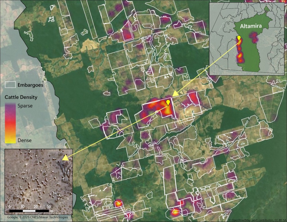
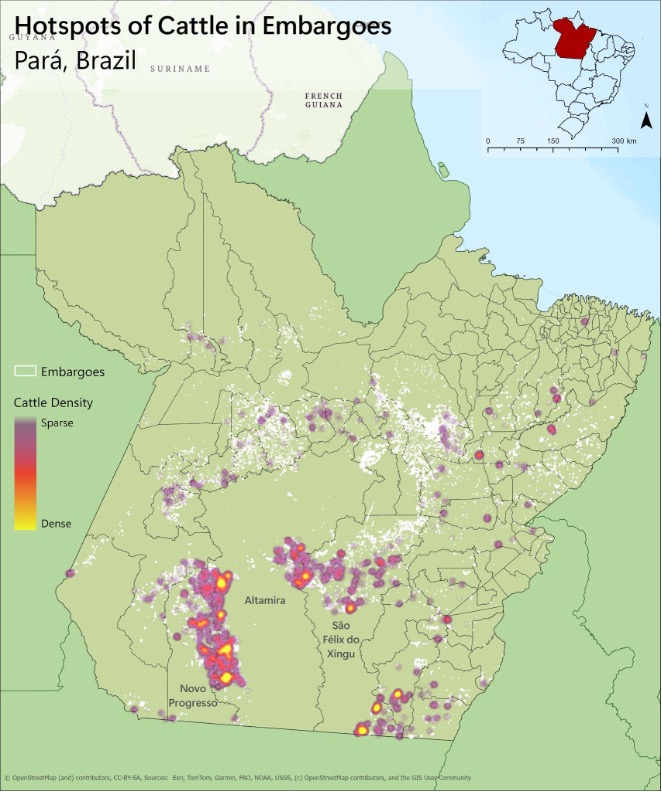
We developed and optimized an AI model to use very high-resolution satellite imagery to map cattle in Pará’s active embargoed areas. We found that, despite the legal restrictions on using these areas, cattle were present on more than a quarter of embargoed areas. This illegal cattle activity was highly concentrated in three municipalities: Altamira, São Félix do Xingu, and Novo Progresso. Next we will be mapping cattle across state-level embargoes and across the entire Amazon.
The persistence of cattle in embargoed areas points to enforcement gaps and the difficulty of monitoring mobile herds across a vast and remote landscape. Our work highlights how new technologies can expose these hidden dynamics. By combining satellite imagery with artificial intelligence, we can now verify the actual use of s anctioned lands and quantify the degree to which the cattle frontier continues to expand.
With colleagues at the GLUE Lab at the University of Wisconsin-Madison, we are launching a new research agenda to strengthen cattle traceability and zero-deforestation policy outcomes, as well as enhance effectiveness of conservation units and indigenous territories. We are collaborating with Erasmus zu Ermgassen at UCLouvain to better understand clandestine “off the grid” cattle across the Brazilian Amazon and to share these insights with policy makers to support the development of solutions. This work draws on the AI-based cattle density model, Leonie Hodel developed, in collaboration with UCAM Conservation and Development Lab Rachael Garrett, Jan Dirk Wegner, Judson Ferreira Valentim and many others. Stay tuned for more updates.
Cite as: Hodel, L., L. Palomino, J. App, L. Rausch, A. Brandão Jr.', and H. K. Gibbs. Cattle Mapping shows Enforcement Gaps in Amazonian Embargoed Areas. GLUE Research Insight. Https://gibbs-lab.wisc.edu/Environmental_embargoes.html